Property Record
630 Claremore Professional Way, Woodstock, GA 30188
Current Lease Availabilities
NEARBY LISTINGS FOR SALE OR LEASE
Property Detail
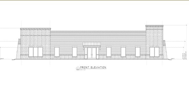
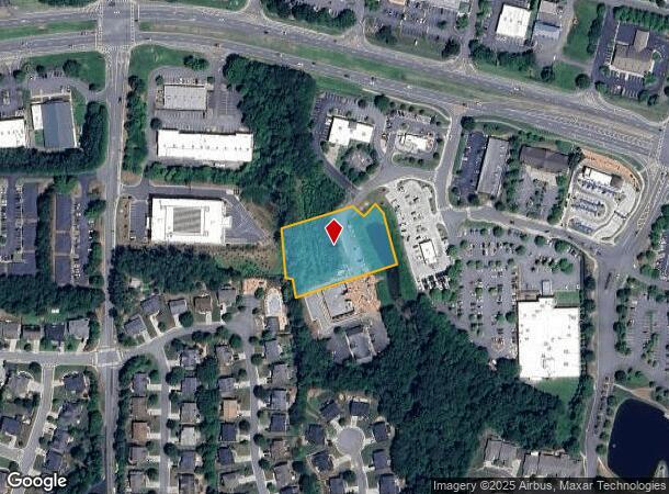
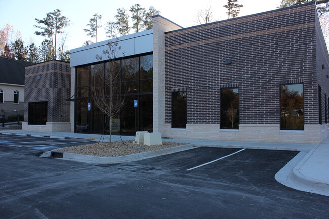
630 Claremore Professional Way
Atlanta-Sandy Springs-Roswell, GA
Claremore Lake
15N24P-00000-103-00D-0000
LOT 3 CLAREMORE LAKE COMM. PROP.
Commercialnec
Cherokee
X
Georgia
13057C0353E
3
2025
1.23 AC
2025
Cherokee County
090906
Atlanta
DEMOGRAPHICS near 630 Claremore Professional Way
1 Mile
3 Mile
5 Mile
2024 Total Population
10,861
63,250
157,565
2029 Population
12,425
69,372
170,360
Pop Growth 2024-2029
+ 14.40%
+ 9.68%
+ 8.12%
Average Age
41
41
41
2024 Total Households
4,181
22,971
57,190
HH Growth 2024-2029
+ 14.59%
+ 10.10%
+ 8.56%
Median Household Inc
$113,173
$112,027
$110,739
Avg Household Size
2.50
2.70
2.70
2024 Avg HH Vehicles
2.00
2.00
2.00
Median Home Value
$317,671
$372,521
$378,975
Median Year Built
2004
1992
1991
Nearby Places
- Restaurants
- Banks
- Shops
- Fitness
- Groceries
Nearby Properties
Address
Land Use
TOTAL SIZE
Lot Size
Zoning
Address
Land Use
TOTAL SIZE
Lot Size
Zoning
604,056 SF
25.03 AC
R-40
Address
Land Use
TOTAL SIZE
Lot Size
Zoning
181,704 SF
17.56 AC
DT-MRA
Address
Land Use
TOTAL SIZE
Lot Size
Zoning
128,196 SF
24.68 AC
R-4
Address
Land Use
TOTAL SIZE
Lot Size
Zoning
266,487 SF
21.69 AC
R-4
Address
Land Use
TOTAL SIZE
Lot Size
Zoning
330,192 SF
20.40 AC
GC
Address
Land Use
TOTAL SIZE
Lot Size
Zoning
328,203 SF
71 AC
R-40
Address
Land Use
TOTAL SIZE
Lot Size
Zoning
161,310 SF
34.63 AC
R-40
Address
Land Use
TOTAL SIZE
Lot Size
Zoning
85,166 SF
3.41 AC
DT-CBD
Address
Land Use
TOTAL SIZE
Lot Size
Zoning
134,017 SF
31.50 AC
R-40
Address
Land Use
TOTAL SIZE
Lot Size
Zoning
186,090 SF
30.08 AC
GC
Address
Land Use
TOTAL SIZE
Lot Size
Zoning
158,427 SF
11.17 AC
GC
Address
Land Use
TOTAL SIZE
Lot Size
Zoning
63,264 SF
8 AC
PUD
Address
Land Use
TOTAL SIZE
Lot Size
Zoning
89,552 SF
14.69 AC
DT-MR
Address
Land Use
TOTAL SIZE
Lot Size
Zoning
50,375 SF
5.77 AC
R-80
Address
Land Use
TOTAL SIZE
Lot Size
Zoning
72,376 SF
12.25 AC
GC
Address
Land Use
TOTAL SIZE
Lot Size
Zoning
135,538 SF
12.34 AC
DT-CMU
Address
Land Use
TOTAL SIZE
Lot Size
Zoning
83,076 SF
10.21 AC
GC
Address
Land Use
TOTAL SIZE
Lot Size
Zoning
35,776 SF
1.50 AC
DT-CBD
Address
Land Use
TOTAL SIZE
Lot Size
Zoning
26,400 SF
1.10 AC
GC
Address
Land Use
TOTAL SIZE
Lot Size
Zoning
87,085 SF
5.01 AC
GC
Address
Land Use
TOTAL SIZE
Lot Size
Zoning
43,403 SF
4.09 AC
OI
Address
Land Use
TOTAL SIZE
Lot Size
Zoning
28,319 SF
0.65 AC
DT-CBD
Address
Land Use
TOTAL SIZE
Lot Size
Zoning
43,942 SF
2.95 AC
GC
Address
Land Use
TOTAL SIZE
Lot Size
Zoning
101,452 SF
5.42 AC
PUD
Address
Land Use
TOTAL SIZE
Lot Size
Zoning
110,180 SF
9.30 AC
GC
Address
Land Use
TOTAL SIZE
Lot Size
Zoning
45,539 SF
4.33 AC
DT-CI
Address
Land Use
TOTAL SIZE
Lot Size
Zoning
26,893 SF
1.83 AC
GC
Address
Land Use
TOTAL SIZE
Lot Size
Zoning
50,614 SF
10.47 AC
GC
Address
Land Use
TOTAL SIZE
Lot Size
Zoning
65,627 SF
35.79 AC
R-40
Address
Land Use
TOTAL SIZE
Lot Size
Zoning
79,905 SF
3.39 AC
NRC
The World's #1 Commercial Real Estate Marketplace
Connect with us
© 2025 CoStar Group
The information above has been obtained from sources believed reliable. While we do not doubt its accuracy we have not verified it and make no guarantee, warranty or representation about it. It is your responsibility to independently confirm its accuracy and completeness. Any projections, opinions, assumptions, or estimates used are for example only and do not represent the current or future performance of the property. The value of this transaction to you depends on tax and other factors which should be evaluated by your tax, financial, and legal advisors. You and your advisors should conduct a careful, independent investigation of the property to determine to your satisfaction the suitability of the property for your needs.